2.5 HOURS 21KM
The conurbation that is Greater Sydney, is intersected by multiple deep creeks and ocean inlet waterways which ebb and flow at the feet of a riddle of ridgelines. Kenthurst
Our ridges may not have high altitudes, but their steep, often sheer slopes form a unique topography, harbouring secret valleys which shelter some rare ecosystems. Kenthurst
Therein lies both the challenge and the delight of exploring our metropolitan bushlands and attempting to link them together. A perfect example is right here, in Kenthurst.
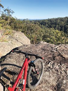 Once the haunt of 4×4 enthusiasts, a set of silent, human powered wheels must now be used to gently and efficiently navigate the off-road areas of Kenthurst today. This 21km bicycling loop is 50% dirt, 50% paved.
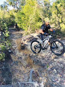
Parking at the end of Cranston’s Road, ride back up for 2kms and turn right into O’Hara’s Creek Road. This is an extreme descent- particularly after the fire trail gate where the semi-concreted surface is like trying to ride on marbles. If you brake too much, the gradient is so steep, your back wheel will literally overtake you!
At the concrete causeway, you’ll notice pretty tree ferns and a tinkling stream. Don’t be fooled, because this steep-sided creek becomes a dangerous, raging torrent given enough rain. Take the old switchback up, off to the right of the causeway, turning right again up past the council gate along Griffin Place to Kenthurst Park. You’ll have to push up all of this, unless you are a skinny cycling machine or you own an e-bicycle!
From here, it’s ‘admire gorgeous acreages time’ as you turn left onto Roughley Road, left again onto Park Road and then right onto Porters Road which is a pleasant and scenic asphalt cruise-mostly downhill- to the Porters firetrail gate.
Porters firetrail is a popular local dog walking area, but the majority of dogs encountered here are off leash. Excercise due bicycle diligence and dismount if your spinning legs are exciting predatory behaviours!
 There are three short loops of lovely technical singletrack to be explored along this ridge line -all on the right hand side of the firetrail.
But the highlight of Porters is unquestionably the lookout above Scaly Bark Creek which frames a forever view straight down the verdant Cattai Creek Valley to the distant blue hills of Kurrajong Heights. This fabulous sheer rock platform is situated at the apex of the firetrail loop-clearly visible on Google Maps satellite layer or Hills Council maps.
From here, ride back up the firetrail and just before the climb starts to get serious, look out for a sneaky little linking singletrack on the left which will pop you out at at another firetrail gate and the entrance to the Pistol Club Shooting Range.
Go through the gate and enjoy riding the next thrilling section of firetrail which despatches you quickly downhill via a series of tight switchbacks back to O’Hara’s Creek. Keep your speed under control as surfaces here are loose, gravelly and therefore slippery. At the bottom, turn right onto the fire trail to savour the absolute best 5kms of this ride.
The O’Hara’s Creek fire trail is named after an early settler of this area who conducted small scale farming activities. Kenthurst
Today, this creek and valley is an ecological wonderland resplendent with rain forest understorey and huge, soaring Blackbutts- their straight, smooth white bark the white marble columns of nature’s cathedral.
This fire trail is the cathedral aisle, the pews are trees and rock formations, the stained glass windows are the way in which light filters through early morning valley mists and the high arches of interlocked tree canopies above. Kenthurst
At the creek causeway, this hallowed ground gives way to the steep climb out to connect with Cranston’s fire trail. It’s a demanding push up with the bike most of the way, but halfway up past the waterfall there is a rough ‘Trail B’ on the left which will take you up to the powerlines loop circling back to Cranston’s fire trail.
Alternately, keep pushing and soon enough you’ll be amongst the rock platforms followed by the powerlines servitude clearing. From here it’s an easy roller coaster romp all the way back to the end of Cranston’s Road and the trail headgate.Kenthurst
FAST FACTS:
Coffee and breakfast are literally just around the corner at the lovely Geranium Cottage.
Detailed trail area maps and information from Hills Council website under ‘bush walks’ tab.
Route described suitable for experienced mountain bicycle riders only. Beginner riders should keep to Porters Road and fire trail.