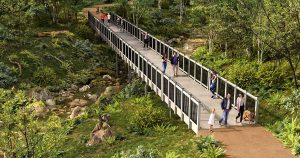
The M7 Shared Path is the longest separated shared path in Sydney. It zigs and zags alongside, over and under the M7 freeway and is just on 40km long, one way. And, unlike the Toll Road, using it is completely free.
Here are a few more reasons why everyone in Sydney should experience this path :
1) One can cycle from Baulkham Hills to Prestons and back (80km!) without having to worry about any motor vehicle traffic whatsoever.
2) Not big on scenic beauty or peace and quiet, the path’s huge popularity is primarily due to personal safety.
3) There are no major hills,* it is mostly flat or undulating. Now that is a rare find in hilly Sydney! This makes it great for kids, the elderly, family/social groups and novices- in fact anyone who simply wants to enjoy a nice cruise on a bicycle. * There is a climb, however, which takes you over and above Elizabeth Road at Western Sydney Parklands. At the crest, the yet-to-beconnected cycle bridge (Exit 41) is where a lot of riders like to stop to admire some panoramic scenery, recover and socialise.
4) Now privately managed by Westlink M7, this path was designed to integrate with other cycle/shared path networks on either side of the toll road to facilitate free active transport options, ie: Prospect Reservoir paths from Parramatta, or Richmond Road paths from Marsden Park, or Sunnyholt Road paths via Glenwood and more. Actually, there are 61 entries or exits to the M7 path, so for local residents, (or for people who work at nearby business parks) there is easy, safe access to and from almost anywhere! The ‘hop on, hop off’ aspect of the M7 path, is one of its major drawcards and makes it possible to ride any distance you feel like; 5km? 50km? 100km?
5) This path is totally unique as it is also well-lit, to facilitate using it at night and for general safety and security.
Really, the only criticism I have heard from the cycling community is that there are no drinking water stations along this path’s 40km trajectory, other than at the Linkt M7 Control Centre which, according to their map, is at entry/ exit 34, just before Wallgrove Road. On weekdays you’ll have the whole 4m wide path mostly to yourself, but it gets busy on the weekends. Start riding at sunrise if you don’t like crowds and bunch riders ! Do be cautious when taking some of the blind bends under or over the Toll Road, because there could be oncoming riders or the occasional pedestrian. Slow down, keep your bike under control and no centre line violations, please!
Fast facts:
MAP: Download the excellent M7 Cycle path Map (WLM7_ SharedPath.pdf) from www.westlinkm7.com.au START & FINISH: I recommend parking or meeting up at Fairmount Crescent, Glenwood. (Just off Norwest Boulevard via Greenhill Drive) Ensure you park in the right place, as Ranger Danger has been known to lurk here.
In February 2016, RMS cycle counters recorded up to 400 cyclists per weekday using the M7 bike path. This number doubles on the weekends. People out cycling have increased since this count. Ensure your bicycle complies to NSW regulations, as Traffic Police officers do patrol the M7 path on their bicycles occasionally.
From Marsden Park Road, cycling east back to Norwest Boulevard, you will always encounter an annoying headwind, so do pace yourself for the return ride.
Take sufficient fluids and snacks for the path distance you intend to cover.


